It has taken a while to properly ponder this letter recieved via Tim Farron MP for Westmorland and Furness, from Andrew Bowie, Minister for Nuclear. In it the Minister for Nuclear accuses me of “harassment” of the CEO of West Cumbria Mining – this harassment amounts to four and a half letters worth written every year since 2020 regarding the alarming and continuing appointment of the coal mine CEO to advise Government on their Delivery of a Geological Disposal Facility for heat generating nuclear wastes. The letters and petition are largely to the Dept for Business, Energy and Industrial Strategy, now the Dept for Energy Security and Net Zero and ask for the removal of the Coal Boss from the Committee on Radioactive Waste Management – the UK Government’s expert voice on geological disposal of nuclear wastes.
The letter and petition of almost 2000 signatures can be seen here.
The reply from Andrew Bowie Minister for Nuclear and Renewables is below with some of my comments in red.
So far the media and it has to be said NGOs have barely raised an eyebrow about this preferring to focus on climate/steel/jobs aspects of the earthquake inducing coal mine just a few miles from what is likely to be the biggest pile of plutonium in the world (the plutonium is not earmarked for a deep geological disposal facility – that would be likely to stay right where it is on the Lake District coast)
“huh whats that weird noise coming from the hole in the wall?” The boy in the bobble hat tilted his head to one side while clutching a load of Christmas shopping. It was cold today with the odd snowflake falling. “Yep its like a weird tune – dunno what it is but that red stuff is coming out thick n’ fast” said the girl through her red fluffy scarf. The children were looking at the Harbour Wall in Whitehaven which had been pouring red pollution out of a culvert for a full year or more. The authorities said there was nothing to worry about in the red stuff gushing from the honeycomb of old mines. Nothing to worry about for the health of the marine life or for humans. But looking at the pollution right now the girl and the boy weren’t so sure. There was a dead great black backed gull with wings outstretched circling slowly around in the water, like the last marshmallow in hot chocolate.
200 Years Earlier
Sweat mixed with coal dust dripped off the girl’s nose as she gripped the reins. “C’mon Flash last haul of the day.” The pony she was leading, whose coat was dapple grey under the coal dust, was pulling a heavy tram of coal on iron rails deep underground. The pony was sweating as much as the girl and ready to head back to the stable. No ordinary stable though – it was huge – for around 50 horses deep under the sea bed. Just a small part of the enormous 500 acres of this pit beneath the sea and the shore of Whitehaven. The labyrinth of deep mined tunnels connected with other pits equally huge all along the coast of Cumberland. As she neared the closed pit doors she heard the small boy humming. He worked in darkness with no light but he made up tunes in his head and hummed them to himself in the darkness waiting to open the doors for the horses. He liked Flash and the girl and gave them an extra special humming tune. In another life he would have been a musician.
Then the girl heard another noise. The man came bursting out of the darkness and tried to grab her but she pushed the lighted candle she held in her hand in his face and he staggered back. The man was a strong fellow, who a few months earlier had his life saved along with that of the lives of the girl and boy. Flash had, by some equine premonition, refused to enter a tunnel whose roof had then collapsed moments later. Now, the boy, who rarely spoke, shouted to the man “leave her alone.” Angry, the man picked up a piece of coal and forcefully hit the small boy on the head, a fatal blow.
The man was sentenced to just one months imprisonment. The boy, who received no justice in life or in death was missed by the girl and by the pony who continued their lives in the dark, deep underground and under the sea. The melodic humming of the small boy was often heard drifting through the mine tunnels by those with ears to hear.
***
An article in the local paper the Cumberland Pacquet of September 1824
““Robert Carter of Whitehaven, was charged with the killing of Peter Andrew the younger. On Friday, 10th September 1824, he approached a young driver, Susan Shaw. She told the court – I was driving a horse and tram in the pit, and the prisoner and the deceased were present. I had a candle in my hand, and Carter coming to me, I put the candle in his face, which raised his anger and he gave me a blow. He was going to his work again when Peter Andrew said: Bob Sponge, what did you strike my driver for ? I heard him in his reply speak very angry to the little boy, so his right arm swing back, and immediately I heard the little boy shout out, and I went to him, and said to Joe Lucas who was present: Robert Carter has kilt the little boy. I found the deceased standing bleeding from the head, there was a wound on his left temple. I believe the blow was given with a piece of coal.”
The above is a story inspired by the “confidence” that West Cumbria Mining have that they will begin a new mine off the coast of West Cumbria in 2024 just five miles from the world’s most dangerous nuclear waste site. A nuclear waste site vulnerable to induced earthquakes which did not exist 200 years ago when Flash the pony saved the boy, the girl and the man in the story from the coal mine roof fall. The “confidence” of West Cumbria Mining is pure hubris as their licence to drill has expired. A new application has gone in from WCM to the Coal Authority for a renewal of their three licences for underground coal mining. The applications are heavily redacted meaning that the public are denied sight of the applications by WCM. But the public CAN write to the Coal Authority and urge them not to approve West Cumbria Mining’s licences to drill. The licence applications can be viewed here https://www.gov.uk/government/publications/coal-mining-licence-applications/coal-mining-licence-applications
A letter has been sent with a petition of almost 2000 signatures urging the removal of the Cumbria coal mine boss from his 2019 appointment to top level nuclear dump advisor. The petition started by local artist and campaigner Marianne Birkby asks for the CEO of the first deep coal mine in the UK in 30 years to be sacked from his key role providing “invaluable advice” to the Committee on Radioactive Waste Management.
CoRWM is an advisory non-departmental public body. It was established in 2003 and has a remit to provide independent scrutiny and advice to UK government and devolved administrations on the long-term management of radioactive waste, including storage and geological disposal. CoRWM provides advice to the Community GDF Partnerships.
A year ago on 7th Dec 2022 Mark Kirkbride’s coal mine was given the green light by the Secretary of State Michael Gove. At the same time the waters of Whitehaven ran red with pollution from the culvert in Queen’s Dock – this is now known to be from the honeycomb of existing mines in the area which campaigners claim may have in part or in whole been reactivated by the nuclear dump advisor’s coal mine borehole investigations and hydrological flushing. The water in Whitehaven continues to run red. Martyn Lowe from Close Capenhurst Campaign has pointed out that “the red water in the harbour is increasing not decreasing – this is a red flag for future mining.”
Campaigners point out that the advice given to the Committee on Radioactive Waste Management by Mark Kirkbride includes using the same preferred suppliers such as Herrenknecht tunnel boring machines as his coal mine and say that ” this is a corruption of any semblence of democracy and is blatant government/business cronyism”. The petition calls for Mark Kirkbride to be sacked from the Committee on Radioactive Waste Management as soon as possible – currently the coal boss is due to be nuclear dump advisor until 2027.
Dear Sir Nigel Thrift, Please find attached a petition numbering 1,714 signatures.
The petition asks for the CEO of the first deep coal mine in the UK in 30 years to be sacked from his key role providing, as you have said “invaluable advice” to the Committee on Radioactive Waste Management.On this day last year Mark Kirkbride’s coal mine was given the green light by the Secretary of State. At the same time the waters of Whitehaven ran red with pollution from the culvert in Queen’s Dock – this is now known to be from the honeycomb of existing mines in the area which may have in part or in whole been reactivated by CoRWM’s nuclear dump advisor’s coal mine borehole investigations and hydrological flushing. The water in Whitehaven continues to run red.
CRONYISM COAL AND NUCLEAR
In reply to a Freedom of Information Request of October 2020 you claim that “West Cumbria Mining and the business interest of Mr Kirkbride, bear no influence on the remit of CoRWM”. However our research through Freedom of Information requests has indicated that Mark Kirkbride’s business interests have undue influence on the remit of CoRWM which is to provide advice to Nuclear Waste Services and Government. One of Mark Kirkbride’s key tasks in his appointment with CoRWM is to provide advice on construction and costings of a Geological Disposal Facility for Heat Generating Nuclear Wastes.
SHARED SUPPLIER LIST
Mark Kirkbride has contributed to a 2020 thesis from the University of Manchester in which he indicates that GDF construction would use the same suppliers as his coal mine. The thesis is called “Waste Disposal Drivers for a Range of Nuclear Power Systems by Kathleen Dungan” The thesis says in Appendix B that “The following costs were sent by Mark Kirkbride (Committee on Radioactive Waste Management (CoRWM)” and the costs include “shafts sunk using Herrenknecht shaft boring roadheader machines (Herrenknecht, 2020a).” In trying to distance themselves from this revelation CoRWM have claimed that Mark Kirkbride gave this information to Manchester University off his own bat – i.e. not with CoRWM’s approval. Whether it was with CoRWMs approval or not this indicates that Kirkbride’s business interests with his coal mine and the remit of CoRWM are mutually interdependent.
TUNNEL BORING MACHINES FOR DEEP MINING (COAL AND NUCLEAR)
Herrenknecht are also named as “preferred suppliers” by West Cumbria Mining – the same named suppliers Mark Kirkbride is advising CoRWM on construction of a Geological Disposal Facility. We would not be surprised to find other West Cumbria Mining “preferred suppliers” are being touted for the investigation techniques and construction of a deep nuclear dump and urge CoRWM to terminate the employment of the West Cumbria Mining CEO as their Geological Disposal Facility (nuclear dump) advisor.
GOVERNMENT LICENCE TO DRILL FOR COAL ALONGSIDE NUCLEAR PLANS
We note that Mark Kirkbride’s licence to drill for coal lapsed in October 2022 and he is looking to government via the Coal Authority to approve a new licence to drill. Clearly Mark Kirkbride cannot be government advisor and hopeful of government approval for licences for his coal mine at one and the same time. This flies in the face of any semblence of democracy and is worthy of the most corrupt of countries especially as the most favoured area for a deep nuclear dump is next to Mark Kirkbride’s business interests in West Cumbria.
At the very least Kirkbride’s contract as CoRWM advisor should be terminated
THE BEST NUCLEAR DUMP ADVISOR IN THE WORLD IS THE COAL MINE CEO? Really??
If CoRWM believe that Mark Kirkbride is the only person in the world CoRWM can turn to for advice on the deep burial of nuclear wastes (deep burial and abandonment is not accepted universally as the safest option) then surely CoRWM should make it clear to Mark Kirkbride that his business interests in West Cumbria Mining should be scrapped. INVESTIGATION In any event we are calling for an independent investigation into how this situation of cronyism has been allowed to continue for so long on what amounts to the most important issue of our time – namely the safekeeping of heat generating nuclear wastes which have to be kept separate from the biosphere into eternity in order to ensure a liveable planet.
Yours sincerely Marianne Birkby Lakes Against Nuclear Dump full address supplied
On behalf of Government, Secretary of State Michael Gove approved the coal mine on 7th December 2022. The CEO of “Woodhouse Colliery” and West Cumbria Mining is Mark Kirkbride. In 2019 Mark Kirkbride was appointed to the Government Committee on Radioactive Waste Management to advise on the UK Government’s nuclear dump plans. His appointment has been extended to 2027. Kirkbride’s “invaluable” role involves: Scrutiny and provision of advice to Government on activities relating to the continued development of a Geological Disposal Facility (hot nuclear dump) safety case Scrutiny and provision of advice to Government on GDF siting activities, including selection criteria, methods of investigation, and the timescale for carrying out site selection in the three rock types Advise on new technologies that could be applicable to the development of a GDF including those in the mining and construction sectors and their potential impacts on a GDF programme. Mark Kirkbride has recently provided costings to Government for the Delivery of a GDF (Nuclear Dump) including advice on enormous Tunnel Boring Machines from the same company (Herrenknecht) which would supply his coal mine. This is a direct conflict of interest. Mark Kirkbride has clearly advised on the hugely damaging seismic blasting which took place in August in the Irish Sea to “investigate” the complex geology for a deep nuclear dump. The enormous area of the Irish Sea in which seismic blasting took take place overlaps Kirkbride’s proposed coal mine. Mark Kirkbride’s ‘investigative boreholes’ for his coal mine may well have led to the reactivation of old mine water which has been pouring out into Whitehaven Harbour for a full year now with no end in sight. The Coal Mine Planning Inspector in his recommendation to Government stated : “the risk of a seismic event cannot be ruled out.” It is beyond belief that the CEO of a seismicity inducing coal mine near Sellafield should be employed by Government as an “invaluable” advisor on nuclear waste burial in a very deep, massive 25km square and very hot nuclear dump. We demand that Mark KIrkbride’s appointment to the Committee on Radioactive Waste Management is terminated. The Cumbrian Coal Mine and the Nuclear Dump Plan are clearly Hand in Hand while Mark Kirkbride Remains as Advisor to Government. This is the dark heart of cronyism and it must stop. We urgently ask that:
Mark Kirkbride’s appointment to CoRWM is terminated
the Cronyism between Mark Kirkbride’s Coal interests and the Nuclear dump plans are investigated by an Independent Inquiry.
there should be a Moratorium on the Nuclear Dump (GDF) Plans
Connections to Russian money investigated – WCM has been bankrolled by Owen Hegarty (now a Director of WCM) who has in turn overseen Siberian coal mine interests being bankrolled by the Russian State.
As representative of the first group opposing the coal mine I was phoned up by Radio 5 Live last night to expect a call this morn at 7.35am to talk on their breakfast show.
The researcher wanted to know what I would be highlighting – I said we had already lobbied to have a traffic light system for earthquakes (brushed aside by the Planning Inspector as part of the conditions on the coal mine) and we would now push hard for that as coal produces more earthquakes than fracking.
Unlike fracking there is no traffic light system in place to halt coal operations should earthquakes occur and that this is especially important as the coal mine is just a few miles from Sellafield.
Also that the coal boss is the government’s nuclear dump advisor appointed to the Committee on Radioactive Waste management in 2019 to deliver a Geological Disposal Facility. This should make the Govnts approval of the coal mine null and void ethically (cronyism) and possibly legally- anyway -needless to say they havn’t rung up but have gone with the ‘safe pair of hands’ of Friends of the Earth who keep to the safe narrative of climate, steel and jobs.
I was also going to say that the coal mine would produce 400,000 tonnes of CO2 a year – this pales to the nuclear waste industry’s 1,046,950 tonnes of carbon dioxide equivalent (CO2e) a year – from the NDA “Using Greenhouse Gas Protocol methodology, the total NDA group carbon footprint for 2019/20 is 1,046,950 tonnes of carbon dioxide equivalent (CO2e)” and the coal boss has been appointed to advise that industry!
The researcher said he didn’t know about all that and agreed it was scandalous – the BBC obviously still don’t want to expose the full truth about the coal mine which is great for our nuclear obsessed govnt..
Photo by Egor Kamelev on Pexels.comFulmar – photo by Dorothy Bennett
The following request has been sent to the Marine Management Organisation (MMO) in the light of West Cumbria Mining’s statement that they “might not need a licence from the MMO” should government approve the plan. Do they know something we don’t given the proximity to Sellafied, the radioactively contaminated Cumbrian Mud Patch (above the mine) and the ecologically sensitive marine protected area of the Irish Sea:
Dear Marine Management Organisation,
West Cumbria Mining have said that “we may not need a licence from the Marine Management Organisation” to mine for coal under the Irish Sea in an area of multiple conservation protections.
Has a pre-application submission been made by West Cumbria Mining for Woodhouse Colliery?
If this is the case I request sight of:
1. Pre-application submission/s from West Cumbria Mining 2. All Replies from the Marine Management Organisation to West Cumbria Mining
Why are the seismic and subsidence issues being ignored by NGOs and media? That is for them to answer. Whatever the reason the ongoing silence it is putting us all at immediate danger of an unlivable radioactively contaminated environment.
This is the latest in the extensive evidence on earthquakes caused by deep coal mining …
Different from the shallow coal seam, in deep mining, the dynamic response of overlying rock has changed significantly due to the high in-situ stresses and complex geological conditions. The frequent occurrence of strong mine earthquakes seriously restricts the safe and efficient mining of deep coal resources. This paper investigates the distribution and evolution of strong mining earthquakes during the process of deep coal seam mining in Dongtan coal mine of China by means of the microseismic monitoring and surface subsidence monitoring technologies. Results show that strong mine earthquakes occurring in the 1st square of the single goaf in each working face take the largest proportion. Most of the mine earthquakes are basically concentrated in the lower hard rock layer in the early mining stage. As the working face advances, mine earthquakes primarily rise straightly to the far-field hard layers. In the early stage of coal mining, the frequency of earthquakes is significantly high. After the mine earthquake goes into the higher hard strata, the frequency of strong mine earthquakes in lower layers decreases. The strong mine earthquake occurs with higher probability when the surface subsidence rate changes rapidly. When multiple layers of hard rock exist, the overburden fracture behaviors become complicated. A large energy mine earthquake in far-field overlying hard strata during deep coal mining is generally caused by the coordinated fracture of multi-strata, which can be reflected by the waveform of mine earthquakes.
Article highlights
The distribution and evolution of strong mine earthquakes during the process of deep coal seam mining are investigated.
As the working face advances, mine earthquakes primarily rise straightly from low field hard strata to the far field.
The strong mine earthquake wave characteristics and surface subsidence behaviors when the earthquake occurs are also investigated.
Not to mention the Subsidence and the Radioactive Mud Patch
This is our response to West Cumbria Mining and the Council’s agreement on conditions should the Secretary of State rubberstamp WCM’s coal mine.
We vehemently disagree with the conditions on seismicity and subsidence as agreed by WCM, the Rule 6 parties and Cumbria County Council. We ask for evidence of justification from WCM for the generous conditions on subsidence and seismicity. The very small concession to monitor all seismicity is meaningless when the limits set at which actions would be taken are generous and the outcome is not to halt operations but for WCM to merely deliver a report.
We are devastated to have been sent the report by (WCM) planning advisors, IC Planning, that: “The Rule 6 parties, Friends of the earth and SLACC, have both confirmed that they have no issuewith the subsidence and seismic activity condition as they are currently drafted. Both parties have provided extensive commentary on a wide range of other conditions and aspects of the proposals, but have not chosen to do so in relation to these specific conditions.” (Note: SLACC have contacted me saying they “do not agree” with the conditions on seismicity and subsidence – lets hope that disagreement from SLACC is voiced in the final conditions).
We agree with the former UK climate envoy John Ashton who has said: “It is morally incoherent” to focus on climate without looking at subsidence of the contaminated Irish Sea bed and induced seismic impacts on the Sellafield site. It will be interesting to see how this all plays out given that the coal boss Mark Kirkbride is employed by Government to advise on nuclear waste plans, his expertise is, after all, in digging very big holes https://www.lakesagainstnucleardump.com/post/government-take-advice-from-coal-mine-boss-over-deep-nuclear-dump-plans .
“WCM can approach these parties and request access to monitor using their electricity and wifi but cannot guarantee permission will be granted.”
RFL Response: WCM must be responsible for providing power and wifi for equipment used in seismic monitoring at high vibration- sensitive and high hazard consequence onshore receptors in the region such as i) West Cumberland Hospital ii) South Egremont boreholes utilised for public drinking water and Sellafield. The receptors should not be responsible for providing electricity and monitoring for WCM.
Unless seismic activity is taking the very long route by road, the shortest distance from the nearest point of the coal mine’s subsea area identified by WCM’s location maps is South Egremont under 4 miles and Sellafield, five miles. Unless WCM can prove otherwise their disingenous claims on distance between the nearest point of the subsea coal mine and the highly vulnerable receptors, should be struck out of official records.
Images – Distances from WCM’s mining interests to receptors, taken from the “as the crow flies” distance calculator http://www.tjpeiffer.com/crowflies.html and WCM’s location map with RaFL additions.
67 Seismic Activity – Investigation
WCM Response
“1mm/s threshold is unreasonable and impractical, – suggest retaining 6mm/s as per original condition.”
RFL Response
What evidence is there that the 1mm/s peak particle velocity threshold agreed by the Planning Inspector during RFL’s contribution to conditions is unreasonable and impractical?
WCM’s 6mm/s PPV is the threshold used for blasting and 1mm/s is the point at which residents will complain of vibrations.
WCM Response
“This is not a fracking project”
RFL Response
If this was a fracking project a stringent Traffic Light System would by legal requirement be put in place – as Cuadrilla have said: “It should be noted that the Traffic Light System required for hydraulic fracturing in the UK is significantly more stringent than the maximum ‘allowed’ induced seismic event for other hydrocarbon industries in the UK such as coal mining where magnitude >3.0ML events have been observed”. Cuadrilla Environmental Statement Appendix 1. Induced Seismicity May 2014 Preston New Road.
WCM Response
“Unreasonable to stop if cause not known. Outside body not defined.”
RFL Response
If the cause is not known operations should be halted until the cause is known. The “Outside body” refers to the appropriate regulatory authority.
68 Seismic Activity – Mitigation
WCM Response
“Suggest the WCM TLS =
C66 – continuous monitoring (Green)
C67 – investigation if PPV > 6mm/s (Amber)
C68 – mitigation if investigation demonstrates WCM at fault (Red) Although a case could be made from the references later to increase the threshold, WCM have not pursued this”
RFL Response – WCM TLS applies only to PPV not to Magnitude of earthquake
C66 – continous monitoring (GreenP
C67 – investigation if PPV > 1mm/s (Amber)
CC8 – halt to operations if investigation demonstrates WCM at fault (Red)
Magnitude TLS Green light a seismic event up to 0.0 occurs operations continue normally.
Amber light: A seismic event between 0 and 0.5ML occurs during mining within the operational boundary (a specified geographical area). Operations continue with caution unless this coincides with a peak particle velocity of 1mm/s and then operations should halt.
Red light A seismic event of 0.5ML or greater occurs within the operational boundary or within the near region up to 5 miles.
69 Subsidence Monitoring
WCM Response
“Prawn fishing in the mud patch and weather conditions are more likely to have an influence.”
RFL Response
What evidence does WCM have that “prawn fishing” and “weather” are more likely to have an influence on resuspending radioactive silts from the Cumbrian Mud Patch than subsidence and climate impacts ?
We have searched for referenced academic research studies of the volume/mass of seabed sediment re-suspension following prawn trawling in, or near, the unique seabed fine sediment feature known as the Cumbrian Mud Patch. We have found no reference to any such studies.
We challenge WCM to provide the referenced academic research data on which they base their claim that sediment re-suspension generated by shrimp trawling and weather factors will generate a greater degree of sediment re-suspension than sub-seabed mining subsidence.
Unless WCM can produce copy of the relevant, fully referenced academic data we urge the Inquiry to regard the WCM statement/claim as spurious and un-substantiated, to disregard it, and to ensure that it is struck out of any record of official proceedings.
If WCM can produce copy of the relevant, fully referenced academic data, we request that the material be regarded as late submitted evidence and that we be granted an extension period in which we can review, consider and respond to this late submitted evidence. If such a time extension is not available or not permitted we formally request that the late submitted evidence be withdrawn and that any reference to the WCM claim be struck out of the record of of official proceedings.
We note that the North Western Inshore Fisheries and Conservation Authority provided an early submission to Cumbria County Council on Subsidence saying:
“impact on shoreline profile and wave heights. NWIFCA note that WCM propose a ‘no mine zone’ within Cumbria Coast MCZ and St Bees SSSI which we welcome. WCM state that “Given the small predicted seabed height changes, the slow rate of subsidence and the small changes in slope, combined with the fact that subsidence will not occur over the whole mined area it is likely that impacts on statutory protected areas in the vicinity of the development (i.e. the Cumbria Coast MCZ and the Solway Firth pSPA) will be negligible”.
This does not dispel concerns over potential for subsidence of the seafloor outside of these Protected Areas which could have impacts on the benthos plus potential consequences to shoreline profile and wave heights, which could in turn result in unintended consequences that would affect these protected sites and elsewhere.Data and understanding are limited at the present time and in order to address this, WCM will commission surveys and a numerical modelling study to more accurately predict the potential impacts, if any, of subsidence on the intertidal and marine environments, to be completed prior to commencement of works.
“Data will also be gathered regarding subtidal communities to determine the distribution, extent and likely responses of any potential sensitive receivers. In addition, a Marine Monitoring Plan will be implemented to monitor the bathymetry of the seabed and surficial sediments properties (including benthic communities) overlying the extraction zones using the data collected in 2016-17 as a baseline”.
NWIFCA would ask who the regulator for subsidence risk is and stress the need for further dialogue and engagement over this issue once predictions of potential impacts have been produced.
The NWIFCA have said that they “will respond formally to an MMO consultation”.
70 Subsidence – Investigation and reporting
WCM response
“Chapter 17 and the HRA did not come to a conclusion that this would occur. CCC have considered this 3 times and have not sought such a condition”
RFL response
It was assumed by the NWIFCA, the County Council and NGOs that the subsea impacts of this coal mine would be scrutinised by a Marine Management Organisation consultation. The onshore impacts from subsea mining induced seismicity and subsidence ( including radiological impacts and the question of who is liable should the “expected subsidence” result in resuspension of Sellafield’s wastes from the mud patch) would be one of the issues given scrutiny in a public consultation by the MMO. However, WCM have said that they “may not need” a MMO licence. What is the evidence for this statement? Has a pre- licence application been submitted behind closed doors ?
71 Subsidence – Mitigation
See above.
Refs North Western Inshore Fisheries and Conservation Authority Ref No: 4/17/9007 RE: Consultation on Further Information submitted in relation to a Mineral County Matter Application for Planning Permission accompanied by an Environmental Statement 29th January 2018 – full document attached“Offshore Subsidence – resuspension and dispersal of radioactive contaminants. The documentation has confirmed to NWIFCA that a risk of subsidence exists and therefore there remains an overwhelming concern over the potential for disturbance and resuspension of radioactive contaminants and sediments.”
The result of this would be that the seismic and subsidence issues having not been addressed by Rule 6 Parties in the Planning Inquiry will also not receive any scrutiny in a public consultation from the Marine Management Organisation. The Mineral Planning Authority of Cumbria County Council has the responsibility to manage conditions for any onshore effects and harms resulting from Woodhouse Colliery should Michael Gove approve the mine. But if their source of origin is subsea, the local planning regime outsources responsibility to the UK government’s Marine Management Organisation, from whom the developers clearly expect a rubber stamp.
If a rubber stamp is to be issued by Government (who employ the coal boss as a nuclear waste ‘disposal’ advisor at the Committee on Radioactive Waste Management https://www.gov.uk/government/people/mark-kirkbridg) it is imperative that a seismic Traffic Light System for the Woodhouse Colliery is implemented. The TLS should be at least as stringent as that for fracking.
“MORALLY INCOHERENT” In his statement to the Planning Inspector, the independent speaker and writer, formerly UK climate envoy 2006-12 John Ashton CBE included the following points. https://www.itv.com/news/border/2021-09-08/cumbria-coal-mine-inquiry-evidence-from-day-two : “it is also dysfunctional that the terrestrial and marine dimensions are being considered separately. I understand the procedural reasons. But it is the consequences of the project as a whole that will shape the lives of those in the firing line. It is both intellectually and morally incoherent, as well as administratively inefficient, to subdivide those consequences: to consider the climate implications, for example, without looking at the risks arising from the destabilization through subsidence and seismicity of Sellafield waste on the seabed above the mine.” Although the former UK Climate Envoys’ statement was widely reported the points he made on seismicity and subidence never made it into the headlines.
EARTHQUAKE TRAFFIC LIGHT SYSTEM FOR COAL MINE NEAR SELLAFIELD? (note: coal mining produces more and bigger earthquakes than the now banned fracking industry.)
Photo credit: David Autumns “The End of an Era”.
A new highly automated submarine coal mine planned for the Irish Sea off the Cumbria Coast “is likely” to cause earthquakes. In a worst case scenario this would affect the Sellafield nuclear waste site. Intensively radioactive holding ponds containing spent nuclear fuel and other high level wastes could rupture, releasing their contents into air, ground water and the Irish Sea.
This is one of the reasons nuclear safety group Radiation Free Lakeland are urging a Traffic Light System at least as stringent as that for fracking to be included in the Conditions being thrashed out now behind the now closed doors of the public inquiry.
Radiation Free Lakeland who did not have the resource to be a Rule 6 Party at the Coal Inquiry are urging all Parties involved in the Inquiry to push for a Traffic Light System as part of the Conditions that will be submitted to the Inspector no later than 29th October 2021.
RaFL say that the existing Conditions to be placed on the coal mine should the Secretary of State Michael Gove give his approval are “beyond generous” especially in respect of subsidence and seismic activity.
The additions made to the Conditions by Radiation Free Lakeland include:
“potential receptors which will be the subject of monitoring which should include the identification of vibration-sensitive and high hazard consequence onshore receptors in the region such as i) West Cumberland Hospital (2 miles) ii) South Egremont boreholes utilised for public drinking water (approx 4 miles) iii) Daily monitoring of seismic activity at Sellafield (five miles), “
“Risk will be mitigated through the implementation of a Traffic Light System where magnitudes of 0.3 and 0.4 are the amber level on the traffic light system and 0.5 is the red light at which operations must be halted.
Green light : A seismic event of magnitude less than 0.0 occurs during mining operations. Operations continue as normal. Daily reports are submitted to regulators ( Coal Authority, Office for Nuclear Regulation, Health & Safety Executive and Environment Agency)
Amber light: A seismic event between 0 and 0.5ML occurs during mining within the operational boundary (a specified geographical area). Operations continue with caution unless this coincides with a peak particle velocity of 1mm/s and then operations should halt.
Red light A seismic event of 0.5ML or greater occurs within the operational boundary or within the near region up to 5 miles. “
“No mineral working shall take place until a Traffic Light System is in place as referenced in advice to the Office for Nuclear Regulation by their expert Professor J Bommer (This paper was produced by Professor Julian Bommer of Imperial College London and was used to inform ONR’s response of 6 February 2019 to Radiation Free Lakeland https://www.onr.org.uk/foi/2019/201904001-3.pdf ). The Traffic Light System to be implemented shall be at least as stringent as that for fracking (as referenced by Professor J Bommer in advice to the ONR) with operations halted at 0.5ML. Note that the TLS would also apply to subsea mining.
Reason: To ensure that seismic activity events are monitored, investigated and mitigated in accordance with policy DC13 of the Cumbria Minerals and Waste Local Plan.”
“In the event that seismic activity which is attributable to onshore (or any subsequent subsea) mining activity at any of the receptors identified at condition 66 exceeds a Peak Particle Velocity (PPV) of 1mm/sec the operator shall halt operations and, carry out an immediate investigation into the reasons for that exceedance.” (note WCM have currently set themselves a generous ‘limit’ of 6mm/sec peak particle velocity – the same as for continous blasting – even at 1mm/sec ppv there will be complaints from local residents of ground vibrations.
Unlike fracking , West Cumbria Mining has enjoyed zero public scrutiny or outraged headlines regarding induced seismicity despite the mine’s location beneath the radioactively contaminated Irish Sea bed and the close proximity of the mine to Sellafield. In contrast to fracking, West Cumbria Mining would not be required to halt operations should induced earthquakes of 0.5 ML occur. Coal mining is known to induce earthquakes of 3 ML and more and the now effectively banned fracking bosses have previously drawn attention to this disparity : “It should be noted that the Traffic Light System required for hydraulic fracturing in the UK is significantly more stringent than the maximum ‘allowed’ induced seismic event for other hydrocarbon industries in the UK such as coal mining where magnitude >3.0ML events have been observed”. Cuadrilla Environmental Statement Appendix 1. Induced Seismicity May 2014 Preston New Road.
The volunteer nuclear safety group say “The seismic and subsidence impacts could release 75 years worth of radioactive wastes accumulated by the UK and much of the rest of the world now sitting at Sellafield and on the Irish Sea bed. There are over 140 tonnes of plutonium at Sellafield, the equivalent of 30,000 Nagasaki’s. The coal mine could yet be the catalyst to End All Eras, after all we are according to the Bulletin of the Atomic Scientists only 100 seconds to midnight. Unless.” ENDS
References and Correspondence with the Public Inquiry regarding Conditions
“The majority of the anthropogenic related earthquakes were caused by coal mining and the decline in their numbers from the 1980s to the 2000s was concurrent with a decline in UK coal production.”
EARTHQUAKES AND SELLAFIELD’S INFRASTRUCTURE: “Sellafield Ltd has modelled the consequences of a reasonably foreseeable seismic event for the site (a 0.25 g acceleration from an earthquake with a return period of once in 10,000 years), which could result in damage to a number of facilities and the release of radioactive materials.” says the Office for Nuclear Regulation in their report: Determination of the Off-site Emergency Planning and Public Information Areas for the Sellafield Nuclear Licensed Site: Radiation (Emergency Preparedness and Public Information) Regulations 2001 (https://www.onr.org.uk/pars/2014/sellafield-14-007.pdf ).
It is suggested that Sellafield’s infrastructure will withstand up to but not including a 9ML (equivalent to approximately 0.25g acceleration) earthquake. However buildings on the site such as the Magnox Silos (x 6) have unknown cracks in unknown silos already leaking radioactive liquor to the ground, this suggests that induced seismic damage in some infrastructure at Sellafield would occur at far lower magnitudes https://www.intechbrew.com/game-changers-storage-silo-challenge/
‐‐‐‐‐‐‐ Original Message ‐‐‐‐‐‐‐ On Tuesday, October 12th, 2021 at 11:59, Shearer, Erin wrote:
Dear Marianne
Thank you for your email detailed below.
Your comments on the conditions sections will be taken into account when the conditions are discussed again with the applicant and Rule 6 parties. If the conditions referred to below are updated at any stage, I will forward those updates to you for any further comments you wish to make. If the conditions referred to below remain unchanged, your comments will be added to the schedule of conditions which will cover the areas or agreement/disagreement and comments upon the same. This schedule will form part of the documents that will be submitted to the Inspector no later than 29 October 2021.
Kind regards
Erin Shearer
Senior Legal Officer
Cumbria County Council
From: Radiation Free Lakeland Sent: 10 October 2021 19:20 To: Humphrey, Elizabeth Haggin, Paul
Subject: Radiation Free Lakeland Amendments to Conditions on Seismicity and Subsidence
Dear Liz Humphries and Paul Haggin
We are very grateful that the Inspector specifically asked for Radiation Free Lakeland’s comments on seismicity and that we be included in the loop about the ongoing conversation regarding these conditions. On subsidence – on thurs 30th September in the Inquiry conditions session , Samagita Moisha from RaFL asked directly for input into the subsidence conditions – so this is included below along with seismic conditions This all relates to Radiation Free Lakeland’s previous written and verbal submissions.
We would like to make it clear that should these amended conditions advised by Radiation Free Lakeland be actioned we would remain unequivocally opposed to Woodhouse Colliery.
With kind regards,
Marianne Birkby
Radiation Free Lakeland
RaFL amendments in red, below Introductory Note
Introductory Note to Conditions 66-71:
There is a basic issue to be overcome in that onshore conditions are the responsibility of Cumbria County Council’s Mineral Planning Authority and that marine conditions are the responsibility of the UK Government’s Marine Management Organisation (should the Secretary of State approve the development, the subsea area of the coal mine may not need an MMO licence). Onshore mining will have effects onshore and subsea mining will also have effects onshore. The Mineral Planning Authority of Cumbria County Council clearly has the responsibility to manage conditions for any onshore effects and harms resulting from Woodhouse Colliery whatever their source of origin onshore or subsea. Seismicity and subsidence which results in onshore harms in Cumbria is the responsibility of the Mineral Planning Authority to manage by way of monitoring. The subsea mining will impact onshore receptors, this should be acknowledged in conditions.
Reasons – It has been noted by marine pollution expert Tim Deere-Jones and others that subsea subsidence “could generate earthquake and liquefaction effects which may extend onshore as far as the Sellafield/Moorside sites.. any seabed subsidence in the WCM designated sub-sea mining zone would generate re-suspension of Cumbrian Mud Patch heavily radioactive seabed sediments. It is noted that such an event would generate elevated doses of man-made radioactivity to coastal zone populations and sea users along both the Cumbrian coast and at “downstream” regions further afield” and that there is “potential for such a radiological effect and the delivery of increased doses of radioactivity to relevant coastal zone communities, some of which have already been identified by the authorities as Coastal Critical Groups.”
Earthquakes and Sellafield’s Infrastructure: “Sellafield Ltd has modelled the consequences of a reasonably foreseeable seismic event for the site (a 0.25 g acceleration from an earthquake with a return period of once in 10,000 years), which could result in damage to a number of facilities and the release of radioactive materials.” In the Office for Nuclear Regulation report: Determination of the Off-site Emergency Planning and Public Information Areas for the Sellafield Nuclear Licensed Site: Radiation (Emergency Preparedness and Public Information) Regulations 2001 (https://www.onr.org.uk/pars/2014/sellafield-14-007.pdf ), it is suggested that Sellafield’s infrastructure will withstand up to but not including a 9ML (equivalent to approximately 0.25g acceleration) earthquake. However buildings on the site such as the Magnox Silos (x 6) have unknown cracks in unknown silos already leaking radioactive liquor to the ground, this suggests that seismic damage in some infrastructure at Sellafield would occur at far lower magnitudes.
CONDITIONS
66 Seismic Activity – Monitoring
1. No mineral working shall take place until a Seismic Activity Monitoring Scheme (SAMS) for onshore mining has been submitted to and approved in writing by the Mineral Planning Authority. The scheme shall include the following:
a) the methodology for monitoring all seismic activity. This shall identify the potential receptors which will be the subject of monitoring which should include the identification of vibration-sensitive and high hazard consequence onshore receptors in the region such as i) West Cumberland Hospital (2 miles) ii) South Egremont boreholes utilised for public drinking water (approx 4 miles) iii) Daily monitoring of seismic activity at Sellafield (five miles), and the equipment to be utilised for monitoring;
b) the location for the installation of the seismic monitoring array to effectively monitor the seismic activity impacts on the receptors identified at (a); and
c) the arrangements including timescales and frequency of reporting the outcome of monitoring to the Mineral Planning Authority, Reporting should be at least monthly ie 12 reports a year to the Mineral Planning Authority unless the peak particle velocity is is in excess of 1mm/s in which case the exceedence is reported immediately.
Once approved, the SAMS shall be fully implemented prior to the commencement of onshore coal mining and shall continue for a period of 6 years after the cessation of onshore coal mining. All monitoring and reporting shall be undertaken in accordance with the approved scheme.
No mineral working shall take place until a Traffic Light System is in place as referenced in advice to the Office for Nuclear Regulation by their expert Professor J Bommer (This paper was produced by Professor Julian Bommer of Imperial College London and was used to inform ONR’s response of 6 February 2019 to Radiation Free Lakeland https://www.onr.org.uk/foi/2019/201904001-3.pdf ). The Traffic Light System to be implemented shall be at least as stringent as that for fracking (as referenced by Professor J Bommer in advice to the ONR) with operations halted at 0.5ML. Note that the TLS would also apply to subsea mining.
Reason: To ensure that seismic activity events are monitored, investigated and mitigated in accordance with policy DC13 of the Cumbria Minerals and Waste Local Plan.
67 Seismic Activity – Investigation
In the event that seismic activity which is attributable to onshore (or any subsequent subsea) mining activity at any of the receptors identified at condition 66 exceeds a Peak Particle Velocity (PPV) of 1mm/sec the operator shall halt operations and, carry out an immediate investigation into the reasons for that exceedance. This investigation should be reviewed by an outside body and will confirm whether or not the seismic activity was induced by mining activity and, if so, identify the mining activities taking place, immediately prior to, the time the exceedance was detected.
The outcome of that investigation shall be set out in a report and submitted to the Mineral Planning Authority within 7 days of the exceedance for approval in writing by the Mineral Planning Authority. (Whether the MPA approves restarting operations; mitigation by change of mining practices or permanent cessation of works)
Reason: To ensure that seismic activity events are monitored, investigated and mitigated in accordance with policy DC13 of the Cumbria Minerals and Waste Local Plan.
68 Seismic Activity – Mitigation
Risk will be mitigated through the implementation of a Traffic Light System where magnitudes of 0.3 and 0.4 are the amber level on the traffic light system and 0.5 is the red light at which operations must be halted.
Green light : A seismic event of magnitude less than 0.0 occurs during mining operations. Operations continue as normal. Daily reports are submitted to regulators ( Coal Authority, Office for Nuclear Regulation, Health & Safety Executive and Environment Agency)
Amber light: A seismic event between 0 and 0.5ML occurs during mining within the operational boundary (a specified geographical area). Operations continue with caution unless this coincides with a peak particle velocity of 1mm/s and then operations should halt.
Red light A seismic event of 0.5ML or greater occurs within the operational boundary or within the near region up to 5 miles.
The following para would be largely superceded if the TLS is in place
Where a seismic activity investigation has been undertaken and reported to the Mineral Planning Authority under condition 67, and where the conclusion of that investigation is that the seismic activity was attributable to onshore mining operations, within 14 days of the receipt by the Mineral Planning Authority of the investigation report, mineral extraction shall cease and a scheme and programme for seismic activity mitigation shall be submitted to and approved in writing by the Mineral Planning Authority. The scheme shall:a)provide the rationale for the development of the mitigation measures with reference to the outcome of the investigation;b)detail the measures to be taken to reduce seismic activity; c)provide a programme for the implementation of the mitigation measures derived from the investigation report; and d)provide for an increase in the frequency of monitoring reporting (this should already be in place) to assess the efficacy of the mitigation measures which have been put in place.Once approved the scheme shall be implemented in accordance with the approved programme.
The developers West Cumbria Mining and the Mineral Planning Authority shall provide liability cover for all onshore impacts originating from subsea and onshore operations including radiological impacts from seismic events impacting on all receptors listed at 66a (this is not an exhaustive list). Liability cover is necessary for compensation to receptors including the already disadvantaged “Critical Coastal Groups” for seismically induced radiological damage.
Reason: To ensure that seismic activity events are monitored, investigated and mitigated in accordance with policy DC13 of the Cumbria Minerals and Waste LocalPlan.
69 Subsidence –
Monitoring
No working of minerals shall take place until a subsidence monitoring scheme has been submitted to and approved in writing by the Mineral Planning Authority. The monitoring scheme shall provide for monitoring the potential effects of subsidence on sensitive receptors. The scheme shall include the following: a)The methodology for subsidence monitoring including establishing the maximum zone of influence of onshore mining by projecting from the outward edge of extraction a line outwards and upwards from the relevant seam at 35o from a line perpendicular to that seam so as to intersect the surface, the methods for recording existing ground levels, method for monitoring changes in ground levels, equipment to be utilised and duration of monitoring following the cessation of onshore mining; b)The subsidence monitoring locations and the rationale for the number of monitoring points and the locations selected; c)The frequency of subsidence monitoring, and the rationale for the frequency selected; d)The arrangements for reporting the outcome of subsidence monitoring to the Mineral Planning Authority which routinely shall be no less than monthly; e)The method for the derivation of trigger subsidence levels at sensitive receptors which would represent a subsidence event; and f) Proposals for increasing the frequency of subsidence monitoring and for the reporting of that increased frequency of monitoring to the Mineral Planning Authority in the event that a subsidence event occurs.
A high hazard, high consequence sensitive receptor of subsidence is the Cumbrian Mud Patch above subsea mining operations. Subsea subsidence and consequent resuspension of seven decades of radioactive wastes will impact public health onshore up to 10 miles inland. Surface subsidence monitoring and reporting shall be undertaken in accordance with the approved monitoring and reporting scheme. Before subsea mining can proceed a 12 month period of daily radiation sampling and monitoring of beaches from Whitehaven to Drigg will be carried out with published findings to establish a baseline of existing radiological impact via the Cumbrian Mud Patch before subsea mining and likely subsidence proceeds.
In the event of a subsidence event under the Cumbrian Mud Patch, the developers and Mineral Planning Authority shall ensure onshore radiological monitoring of beaches are carried out. Timescales, methods and reporting for onshore beach monitoring regarding resuspension of radioactive wastes from the Cumbrian Mud Patch are to be approved.
Reason: To ensure that subsidence is monitored, investigated and mitigated in accordance with policy DC13 of the Cumbria Minerals and Waste Local Plan.
70 Subsidence – Investigation and reporting .
In the event that a subsidence event occurs, the zone of influence of the sensitive receptor shall be established by projecting downward and inward at an angle of 35o to the depth of seam being worked. Coal production within the zone of influence of the sensitive receptor shall be suspended until a subsidence investigation has been completed. The subsidence investigation shall determine the reason(s) for the subsidence event. The investigation shall review the mining activities taking place prior to the subsidence event being detected and determine which of these activities led to the subsidence event occurring. The findings of the investigation shall be set out in a subsidence investigation report which shall also identify the mitigation measures and a programme to be adopted to prevent a reoccurrence of a subsidence event. Where a subsidence investigation report has been concluded it shall be submitted to and approved in writing by the Mineral Planning Authority. Any mitigation measures shall be carried out in accordance with the Mineral Planning Authority’s written approval and the approved programme.
The developers West Cumbria Mining and the Mineral Planning Authority shall provide liability cover for all onshore impacts including radiological impacts from one or more subsea subsidence events impacting on the contaminated Cumbrian Mud Patch. Liability cover is necessary for compensation to receptors including the already disadvantaged “Critical Coastal Groups” for subsidence induced radiological damage. Reason: To ensure that subsidence is monitored, investigated and mitigated in accordance with policy DC13 of the Cumbria Minerals and Waste Local Plan.
71 Subsidence – Mitigation
Coal mining shall only recommence within the zone of influence of the sensitive receptor which was the subject of the subsidence event under condition 70 after the Mineral Planning Authority provide written notification to confirm approval of the investigation report and that the proposed mitigation measures are acceptable.
As noted in condition 70 mitigation measures should include compensation to “Critical Coastal Groups” exposed to increased radiation dose via the resuspended Cumbrian Mud Patch. Liability insurance should be in place to mitigate costs of remediation and compensation for onshore impacts of subsea mining.
Coal mining within the zone of influence of the sensitive receptor which was the subject of the subsidence event shall thereafter only take place in accordance with the mitigation measures approved within the subsidence investigation report.
Before subsea mining can proceed a 12 month period of daily radiation sampling and monitoring of beaches from Whitehaven to Drigg will be carried out with published findings to establish a baseline of existing radiological impact via the Cumbrian Mud Patch before subsea mining and expected subsidence proceeds. The developers West Cumbria Mining and the Mineral Planning Authority shall take full responsibility for compensation for injury to person and property to receptors impacted by the expected subsidence events. This will include onshore impacts such as radiological mitigation of impacted beaches. Reason: To ensure that subsidence is monitored, investigated and mitigated in accordance with policy DC13 of the Cumbria Minerals and Waste Local Plan.
CLICK ON THE COMMENTS ICON ABOVE TO VOTE NO..If you are on social media there is an opportunity to Vote No to the coal mine – the Whitehaven News has a poll which is so far being populated by pro-mine votes – come on lets show resistance to this diabolic plan which is far more dangerous than the sum of the climate/steel/jobs arguments being promoted.
Q. When is a Coal Mine More Dangerous than the Sum of its Parts??
A. When the Coal Mine Boss is “invaluable” to the UK Government’s Nuclear Dump Plans
This article was written in early 2017 and sent out to local and national groups and commentators with the aim of raising opposition to the coal mine – that was achieved but the many headed hydra in the room is still being studiously ignored. Our nuclear obsessed government are only too happy about that – the last thing they want is to draw attention to the insanity of mining out earthquake inducing huge voids under the Irish Sea adjacent to Sellafield. What a nightmare.
From early 2017….
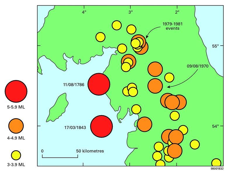
Most Gaseous, Dangerous Pit in the Kingdom These are strange, confusing days. There is all round praise being heaped on the plans to reopen Whitehaven coal mine on Cumbria’s West Coast, the most gaseous, dangerous pit in the Kingdom. In 1815, Sir Humphrey Davy’s invention of the miner’s safety lamp was first tested in Whitehaven Coking Coal Mine because of its reputation for “firedamp” (methane) and fatal explosions. By 1816 the Davey lamp was in full use in collieries around Great Britain. A letter of gratitude was written by Whitehaven Miners to Sir Humphrey Davy in 1816…. many of the miners signing the letter later lost their lives in the mine. Honeycomb The West Coast of Cumbria below both ground and sea is a labyrinthine honeycomb of mines. Not only coking coal but iron ore and many other minerals. This vast honeycomb of mines stretches to Sellafield. One of the earliest records of coal mining in West Cumberland dates to 1560, the last pit, the Haig, closed in 1986. There are old mine maps but these are far, far from complete. Understandably so, given the length of time that this area has been extensively mined. Many of the miners are still there in the dangerous honeycomb. Entombed in the same collapsed and sea inundated mine pits that the West Cumbria Mining Company wants to reopen. Infamous Copeland By Election In the recent infamous Copeland by election the candidates without exception declared themselves to be “big fans” of reopening the West Cumbria Coal Mine. They did this in true Alice in Wonderland style, expressing concerns about climate change while praising the plan to reopen the coal mine. For many years UK citizens have been subjected to a constant bombardment of disingenuous propaganda: ‘nuclear power is the answer to climate change and coal is far worse than nuclear for the climate’. The purpose of this propaganda being that we should welcome nuclear with open arms, while shunning coal. George Monbiot has consistently and aggressively set the pace: “Nuclear scare stories are a gift to the truly lethal coal industry.” Monbiot’s constant mantra in the last several years is that those who oppose nuclear power are uninformed, bigoted idiots. Now it appears that the idiots in Cumbria are being groomed to welcome both coal AND nuclear. Homely Image A recent article in the Daily Mail paints a homely image of a local mining firm returning to its traditional roots in Cumbria. This image is not quite what it seems. The £14.7m private equity financing for reopening Whitehaven mine has been put up by EMR Capital who say: “We are a specialist resources private equity manager whose team has a proven track record in the three dimensions critical to achieving superior returns:
Successful resources exploration, development, operation and commercialisation
Deep linkages to Asian markets – in particular, with commodity purchasers and end users, resources companies, investors and governments
Private equity investment management”
PR Spin The PR for reopening the coal mine seems to have worked its charms on the local Allerdale and Copeland Green party for whom the coal mine gets a thumbs up as it ‘will reduce imports of the coking coal necessary to produce wind turbines.’ This argument holds no water as in order to recoup money and make a killing the coal from Whitehaven would be aggressively exported worldwide. The coal and its by-products could end up doing anything from being burnt in coal fired power stations, processed into coking coal, making the vast amounts of steel necessary for a giant geological dump for radioactive wastes. The coal from Whitehaven was first processed into coking coal for the iron industry in 1723. Coke production did not however match local demand and tonnes were brought in from Durham. The Durham coke was superior in having lower phosphorus content, a factor of importance to the local hematite iron industry. Turning the ground to a liquid mess There are other ways to achieve the high temperatures necessary for steel production but even if processing coal into coking coal was the only way, the close proximity of Sellafield and the proposed Moorside site should knock this dangerous plan on the head. Extractive activities are known to cause earthquakes. There are two contenders for the strongest earthquake in this region a 5.0 ML earthquake on 11 August 1786 had an epicentre just offshore from Whitehaven and a depth of about 16 km; a 5.1 ML earthquake on 17 March 1843 had an epicentre offshore from Barrow and a depth of about 15 km. This may not be unrelated to the escalating mining activities going on the time. The only area in the UK to have experienced a liquefaction event is the village of Rampside, near Barrow in 1865. “High intensity and liquefaction phenomena are usually associated only with relatively large magnitude earthquakes. An earthquake in 1865 in the North West of England suggests that a sufficiently shallow small event can also produce liquefaction. The effects are well documented in historical sources and include sand fountaining. Modern investigation is confined to documentary evidence owing to the tidal environment of the area where liquefaction occurred. Analysis shows that the felt area of the earthquake was probably only about 200 km2; however, heavy damage occurred in the village of Rampside and the maximum intensity is assessed at 8. Liquefaction is not uncommon at this intensity, but such a high intensity is not usually produced by such small earthquakes. The magnitude was probably in the range 2.5–3.5 ML.” pure and applied geophysics November 1998, Volume 152, Issue 4, pp 733–745 Questions West Cumbria Mining are inviting the public to ask questions so I asked the following: “How would the mine be dewatered? What is the full carbon footprint for one year of peak production. Including predicted dewatering, mining and export operations? What agreements have been made with St Bees School, Lowther Estate, regarding the mineral rights? How are the vast network of faults and dips mapped? (this would have a bearing on distance to the sea bed) What is the proximity to the proposed Moorside site and Sellafield?” The reply from Communications Manager Helen Davies was: “At this time I am busy preparing for our next major stakeholder event, which is scheduled to run on the 2nd, 3rd and 4th March. It would be much easier to discuss your questions and provide answers from our team of specialists who will be at the event, rather than attempting to answer them in writing now. The event on the 2nd March is by invitation only – please find attached an invite, we would be delighted if you could come along to meet with us. Caroline Leatherdale, our environmental specialist will be there, together with a wide range of our technical team.” Does your lump of coal feel lucky?” Marianne Birkby Radiation Free Lakeland some more info… Earthquakes http://earthwise.bgs.ac.uk/index.php/Geological_hazards,_geology_and_man,_Northern_England http://earthwise.bgs.ac.uk/index.php?title=File:P916108.jpg&filetimestamp=20160412172238& http://www.westcumbriamining.com http://www.westcumbriamining.com/local-news/west-cumbria-mining-outline-new-plans-coking-coal-mine-near-whitehaven/


